Cities: Skylines II

  • Thread starter PJTierney
  • 157 comments
  • 21,774 views
Looking at all these fine-looking CSII screen shots along with trying to figure out why some aspects of my own cities never quite look 'right' i've realised that the blank canvases we start with don't really accurately represent the enviroment where real life cities spring up. Certainly not in Europe.

You don't just get endless grass plains. You get farm land with walls and hedgerows, small wooded areas and small roads. I recently came across some victorian-era photos online of the area where i live, some showing roughly the view out over the valleys that i get from my home office window. Even though they're over a century old now the dozen or so houses you could make out largely all still exist today. The roads/tracks that linked them are roads i'm familiar with but now on a greater scale. Where my IRL city has expanded out into what was then countryside, it did so by taking over farm land. Where i now see estates of 1950's semi-detached houses and a couple of 1960's tower blocks, the old photos just show small fields and their boundaries and those odd few houses scattered in between.

It's a shame the tiles we begin with don't reflect this better in game. @eran0004 pictures above and @HarVee at the top of the page look great and those cities have nice realistic looking layouts, but they're 'spoilt' by the areas not yet built on. It wouldn't be grass plains with a smattering of trees, it would be farm land. Sure, it's something you could replicate, especially now with the way farmland fields can be generated, but i think it would be better if these things existed to be built over (or not) in the first place.
 
Last edited:
but i think it would be better if these things existed to be built over (or not) in the first place.
I certainly don't disagree, also being from the UK, things like decent hedge networks, different field 'coverings' with a tractor track network would really help as well.

It's interesting to see what lays around cities and towns in various different parts of the world. Without mods the selection of buildings is very limited, but once we get new assets that can be tailored to specific regions it would be good to get other tools that allow the player to make the surrounding area as much a part of the localisation as the built up areas.


1710770136283.png

1710770032556.png

1710770043024.png

1710770056750.png

1710770068458.png

1710770082526.png

1710770097227.png

1710770106375.png
 
Yeah, a nicely made countryside makes a big difference. The problem is that it’s such a huge area that it takes a lot of work to fill it in. In CS1 I wrote a Python script that would plant the forests automatically based on an image mask and a specified density, hopefully it will be possible to do something similar in CS2 once modding gets supported.

Speaking of which, seems like Paradox Mods will go live with map editing and code mods by the end of the month, so my vanilla days may soon be gone :cheers:

Edit: Here is the tree script in action in CS1. The first iteration was kind of slow (still a lot faster then placing the trees manually), but later versions were much faster.

 
Last edited:
The map editor will become available on the 25th of March. Seems like you can customise the climate in detail, including the chance of clouds, the chance of snow, the length of seasons and how quickly the weather may change. Resource painting can be done via mask images (which I’m sure it’s a feature that won’t be abused by anyone), but it doesn’t look like that functionality will extend to tree placement.

 
I started experimenting with transition curves again. They are quite easy to build manually, with the information about road length and turn angle. I'm working on a spreadsheet to help with the design.

07-april-15-20-54-00.png
07-april-20-24-47-02.png
 
The transition curve spreadsheet is ready for testing. I’m not sure how to share it without making every user edit the same document, so if anyone knows how it can be done please let me know 😁


Link to edit
 
Last edited:
I decided it was time to test the map editor. I'm going to try to create an island map, similar to the ones I made in CS1, will be interesting to see if it's possible to build a city with only ship connections to the outside world.
So far I've loaded a heightmap and a worldmap and started shaping the terrain, these cliffs turned out great! I'm going to try changing the map texture as well, and figure out some smart way to paint the forests.

Skärmbild (240).png
 
Trees are done :)
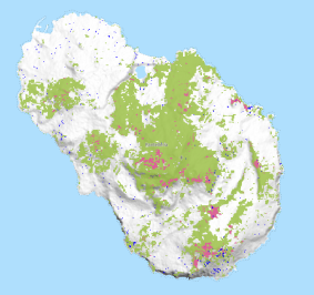
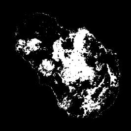
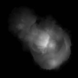
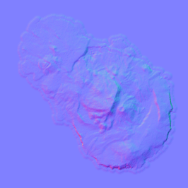
I went to to https://www.globalforestwatch.org/map/ and screengrabbed a map of the forest coverage on the island, then I created a PNG mask of it in GIMP and loaded it in the map editor as a resource mask for fertile land. That way, the mask appears as a yellow overlay on the landscape and it's pretty easy to just fill it in with trees. I went for a mix of popplar, oak and alder. Then to get some variation I created a second biome, where above a certain elevation as well as for terrain that faces north I replaced the oak trees with spruce. This was done by creating a normal map from the height map and isolating the green channel, then combining it with the forest mask and the heightmap and setting appropriate threshold values. The result was loaded into the editor as an ore resource mask, which appears blue on the map, or green when it overlays with the fertile land mask. Then it was just a matter of deleting the oak trees from the green areas and replacing them with spruce.

Next I would like to customize the climate, but it seems like that functionality is not available in the editor yet so I guess I'll have to wait for an update.

As for my impressions so far, I really like that the "world" stretches out so far from the playable area, it works especially well for an island like this.

Skärmbild (242).png
Skärmbild (243).png


Here are the resources I used.

1. The tree cover map from Global Forest Watch, and next to it the forest mask created in GIMP.
forestwatch.pngpantalleria_forestmap.png

2. The heightmap, normal map and the spruce mask created from them.
heightmap_11.988407454727849_36.78684689547619_57.344.pngNormalMap.pngpantalleria_sprucemap.png
 
Last edited:
Back